The game of golf has been around for centuries, and is arguably at the peak of popularity today. While the rules have remained mostly the same all these years, technological advancements have seen the game evolve. And now, drone technology is about to substantially change how tournament players approach the game.
“Typically, the courses that host United States Golf Association [USGA] championships will provide a program in the form of a booklet, which can be anywhere from 20 to 100 pages,” explains David Jacobsen, co-chair of the U.S. Senior Women’s Amateur Championship, held this year at Waverley Country Club in Portland, Oregon. “It includes static pictures of the course, welcome letters to the competitors, advertisements, and so on. Last year, I attended a media and publications meet held by the USGA, and someone said, ‘We’re waiting for one of our host clubs to do the first-ever digital program.’ Right then, a light bulb went off in my head.”
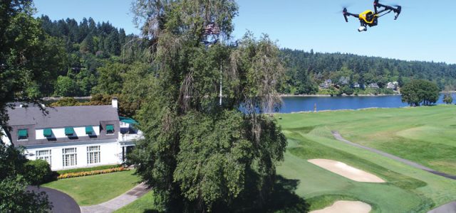
Given Oregon’s status as a national leader in the drone industry, Jacobsen decided early on that he wanted the program to include an aerial tour of the course. So, he reached out to the Roswell Flight Test Crew in Portland for drone consulting. “My goal was to give the competitors coming to the championship, our members, as well as their guests, a much deeper context about the course and how it plays,” he says. “I really wanted to capture that three-dimensional perspective, which you just can’t get from a still photograph.”
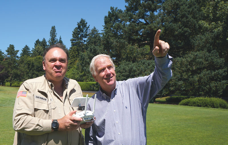
Patrick Sherman of the Roswell Flight Test Crew (left) takes direction from David Jacobsen as he captures aerial video of the historic Waverley Country Club in Portland, Oregon. A lifelong golfer, Jacobsen volunteers with the Oregon Golf Association, as well as with the United States Golf Association.
A Family Affair
Established in 1896, Waverley is truly a historic golf club. As we toured the course, Jacobsen pointed out a barn that once housed the horses that pulled the gang mowers that were used to maintain the fairways before gasoline-powered models were available. The club’s driving range was established on what had previously been the polo field.
“This really is a special place,” says Jacobsen. “When I make that turn into the driveway and come up that short hill, it feels like I’m coming home.”
As a student, Jacobsen worked as a greenskeeper at Waverley, the same club where he is now a prominent and active member. “Everyone in my family played golf,” he says. “At one point, there were six of us playing, and we had a combined handicap of 26.” (For the benefit of non-golfers, he adds, “That’s pretty good.”) His brother Peter went on to a successful career as a professional golfer and now travels the world as a broadcast commentator on NBC Sports golf telecasts. Peter Jacobsen volunteered to do the narration that will accompany the video, calling out the unique features and hazards associated with each hole.
On Par
Like any commercial drone operator, my first step was to make sure that I would be operating in Class G airspace; otherwise I would need permission from the Federal Aviation Administration to conduct the flight. This was not a step I could take for granted, as Waverley is less than nine miles from the perimeter fence at Portland International Airport (PDX), which serves 18 million passengers annually from within its protective rings of Class C airspace.
Consulting my sectional, I discovered that the outermost circle of PDX’s airspace did indeed encompass Waverley. However, this indicated a “shelf” of controlled airspace, with its floor 1,700 feet above the country club’s manicured greens, with Class G airspace below, so I was cleared for takeoff. With Jacobsen standing beside me and watching the live video feed from the drone over my shoulder, I conducted a series of maneuvers at each hole: a direct vertical ascent from the tee box to provide general orientation, a flight down the fairway from the tee to the green, and then a final shot orbiting the green itself.
It took us about four hours to capture video of all 18 holes — about the same amount of time required to play a round of golf. That worked out well, because there were golfers on the course while we were working, and maintaining an equivalent pace ensured we would have each hole all to ourselves.
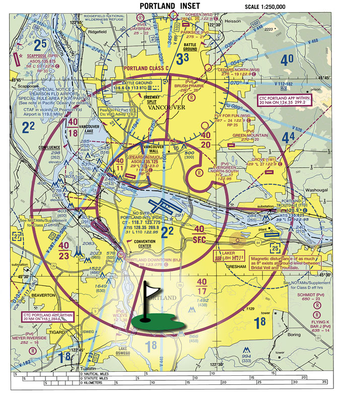
The location of Waverley Country Club is superimposed on the airspace surrounding Portland International Airport, as depicted in the current Seattle Sectional Chart. The magenta lines indicate the boundaries of the Class C airspace surrounding the airport.
Playing Through
Waverley was selected to host the tournament in 2014, and planning has been underway ever since. When the golfers tee off on September 9, Jacobsen is convinced that having the drone video to consult will have been a benefit to them. “These views are about as close as you can get to the experience of playing the course without ever actually being here,” he says.
The site of our drones buzzing overhead drew attention from the club golf course superintendent, who had his own thoughts on how aerial imagery might be a benefit. “He was extremely interested in what he saw us doing,” Jacobsen says. “He thought it might be useful from a turf care perspective and a maintenance staff training perspective. I think drones may have more to contribute to the sport than just course previews.”
—Patrick Sherman