Surveying

Anafi 1.5.6

Drones & Dams

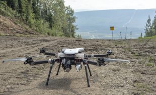
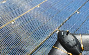
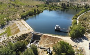
They’re quiet, they capture crucial high-definition images and, most of all, they’re safer. Widely used in utility equipment inspections and wildfire mitigation efforts, drones have quickly become an essential tool for Southern California Edison (SCE) in its dam safety inspections, too. With 83 dams in SCE’s hydroelectric system stretching from Catalina Island to Big Creek near […]
Team Bath Aurora

Team Bath Aurora

Team Bath Drones was founded in 2015 as a competitor for the IMechE UAS Challenge. Since then they have entered a new aircraft each year with great success. Each year they start from scratch, first as a paper design exercise in their third year, and then as a voluntary team in our final years. Their […]

Ads after 2 posts

Terra Drone Tests Ground Penetrating Radar

Terra Drone Tests Ground Penetrating Radar

Terra Drone Indonesia is testing a drone equipped with Ground Penetrating Radar (GPR), with PT Airborne Geophysics Indonesia and the Bandung Institute of Technology (ITB) Geophysics Lab. Ground Penetrating Radar (GPR) is one of the tools needed to model soil structure.  In this trial, the drone carrying the GPR sensor was flown over tunnels and underground […]
Terra Drone Inspects Flare Stacks

Terra Drone Inspects Flare Stacks

Terra Drone Indonesia, a group company of Japan-based Terra Drone Corporation, has conducted drone-based visual inspections of onshore flare stacks for energy major Chevron (PT Chevron Pacific Indonesia). The drone-based flare stack inspection was done in Duri field, one of the largest production fields in Rokan PSC, Sumatra. Using a multirotor drone equipped with high-resolution […]

Ads after 2 posts

Monitoring Endangered Sea Lions

Monitoring Endangered Sea Lions

In this video, the South Australian Bight National Marine Park is using drones to survey endangered Australian sea lions, who live and breed on sheer cliff faces and rock ledges. Hunted to the verge of extinction, the endangered Australian sea lions refuge in the waters of the Great Australian Bight, with about 80% of the […]
Pensa Drone Checks Store Shelves

Pensa Drone Checks Store Shelves

For retailers, empty or incorrectly stocked shelves come with a high price tag. New startup Pensa thinks drones can help, giving close-to-real-time updates on in-store inventory to both retailers and brands. It’s a lightweight alternative to the armies of cameras that track a customer’s every move in Amazon Go convenience stores. The Pensa Systems drone […]

Ads after 2 posts

Navy Drone Finds Corrosion

Navy Drone Finds Corrosion

“Topside Drone” is a development of a corrosion/anomaly detection sensor payload and processing scheme, outfitted to a commercial-off-the-shelf (COTS) UAV. The technology will inspect and detect material defects, corrosion, warping and other conditions plaguing naval vessels. The drone flies around the area of inspection and takes photographs and measurements for evaluation to determine if corrosion […]
Autonomous Drone Flight Over Trans-Alaska Pipeline

Autonomous Drone Flight Over Trans-Alaska Pipeline

Echodyne, the manufacturer of innovative, high-performance radars for government and commercial markets, announced today that its EchoGuard airspace management radars were the ground-based sensor for the first-ever UAS mission to operate beyond-visual-line-of-sight (BVLOS) flight without ground observers. The ground-based sensors worked in coordination with Iris Automation’s onboard detect-and-avoid system. The demonstration of a nearly four-mile […]

Ads after 2 posts

Percepto’s Autonomous “Drone-In-A-Box” Flies On 5G

Percepto’s Autonomous “Drone-In-A-Box” Flies On 5G

Percepto today announced that it has successfully demonstrated its autonomous drones over SK Telecom’s 5G trial network. SK Telecom is the largest mobile operator in Korea, leading the world in the field of mobile telecommunications by commercializing its 5G network in December 2018. Dain SNT, Percepto’s representative in Korea, has been collaborating with SK Telecom […]
senseFly introduces Solar 360

senseFly introduces Solar 360

senseFly, leading provider of fixed-wing drone solutions, introduced its new senseFly Solar 360 at this year’s AUVSI XPONENTIAL, the latest addition to its senseFly 360 solutions range. Created in collaboration with software company Raptor Maps, this new offering is a uniquely efficient thermal drone solution that enables the automatic assessment of solar plant performance at a sub-module level. […]
Air Age Media ©
WordPress Video Lightbox Plugin
RotorDrone