Portland, Or, has a love-hate relationship with the Willamette River, which flows right through its heart and gives the city one of its most picturesque nicknames, “Bridgetown.” Such an attitude may seem at odds with the city’s reputation as an Eco-topia: Portland is home to the largest urban park in the U.S. and has a mass transit system that is the envy of the civilized world. Unfortunately, the city also had a combined storm water and sanitary sewer system that would cause sewage to overflow into the Willamette whenever it rained. After hearing public health warnings about the river for decades, not a single bicycle-commuting locavore in the entire city would voluntarily go within 100 yards of it.

Above: The waterborne crowd participating in the Big Float looks up and waves at RQCX-3 Raven as she hovers nearby capturing still photographs that will be used to promote the event in future years — and ultimately heal the rift between the city and its river.
This slow-motion environmental catastrophe came to an end in 2011, after the city literally poured $1.4 billion down the drain as part of a 20-year project known as the “Big Pipe.” While nothing short of a deluge would cause the sewer to overflow into the river, for many the thought of a swim in the Willamette still seems about as appealing as buying a vacation home on the outskirts of Chernobyl.
Changing this perception is the mission of a self-appointed group of river boosters who call themselves “The Human Access Project,” or HAP.
The Big Float
Giving people easier access to the water is the group’s core mission, and HAP ringleader Will Levenson needed an aerial perspective to show city engineers the changes he wanted to make to the existing landscape, so that it would be easier for people to walk down to the water’s edge. (That’s where our rotordrones come in!) Of course, a mile of pristine, white sand beach a short walk from the nearest light rail station isn’t going to benefit anybody if they don’t think it’s safe to go in the water, so Levenson inaugurated the Big Float. Once a year, he gets together with a couple thousand of his friends and they float down the river on air mattresses and other pool toys of every conceivable shape and size — proving conclusively that the river is safe.

Above: Portland, OR, is a city defined by the Willamette River and the bridges that cross it. However, until 2011, city residents would not have dared to swim or wade in its waters for fear of coming in contact with untreated sewage. Thanks to a $1.4 billion public works project, the river is now clean and safe to enjoy.
A view from above
Of course, if photographs are good, aerial photographs are better — especially when it comes to showing thousands of people floating on inner tubes and giant, inflatable swans, stretched out over a half mile of river.

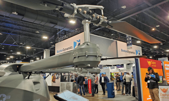
Above: RQCX-3 Raven hovers near the Hawthorne Bridge, one of Portland’s 10 iconic spans that provide passage for vehicles and foot traffic across the Willamette River.
During the Big Float this summer, our RQCX-3 Raven hexacopter flew sortie after sortie, gathering high-definition video and still images of the event. We provided them to HAP and they, in turn, used them to convince a few more people that the river is a safe, fun place to spend a hot summer day.
Someday, many years in the future, every citizen of Portland will feel comfortable wading into the Willamette, and it will no longer be necessary to explain why a city that loves the environment hates its own river.