Aerovironment announced it is supporting the National Park Service Inventory and Monitoring Program to assess the environmental impact of the Woolsey wildfire in the Santa Monica Mountains National Recreation Area of Southern California. Burning over 96,949 acres, the devastating Woolsey wildfire destroyed more than 616 park structures and consumed approximately 88% of National Park Service land within the recreation area. Considered one of Los Angeles’ most cherished open spaces featuring hiking trails and historic structures, the Santa Monica Mountains National Recreation Area is also home to a wide variety of indigenous plants and animals, including multiple protected and endangered species.
Working in close collaboration with National Park Service park rangers and scientists, AeroVironment Commercial Information Solutions Unmanned Aircraft Systems flight operations and Geographic Information Science teams have initiated a comprehensive drone-based aerial imaging and environmental impact study to assess fire damage in key areas of the park. Aerial imagery data collected will be used to quantify oak tree mortality and vegetation stress, in addition to documenting the dramatic changes in park visitor experience.
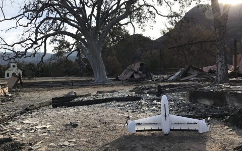
Utilizing AeroVironment’s Quantix™ hybrid drone and Decision Support System (AV DSS™) advanced data analytics platform, the team captured and analyzed high-resolution drone-based aerial imagery to quickly map the affected burn area, and gain actionable insights into the scope and scale of the damage. In addition to immediate disaster response and damage assessment, data collected will facilitate the development of a long-term environmental recovery and park rebuilding strategy.
Purpose built for commercial applications including precision agriculture, infrastructure and mining operations, the Quantix hybrid drone innovative VTOL technology allows it to operate effectively in a variety of conditions, and can survey up to 400 acres in just 45 minutes. During flight, Quantix integrated sensors capture high-resolution RGB color and multispectral imagery via dual 18MP cameras. On-board processing delivers true color and normalized difference vegetation index (NDVI) maps on the Quantix control tablet as soon as the drone lands, allowing teams to ground-truth potential issues immediately. For more detailed analysis, the AeroVironment Decision Support System (AV DSS) performs advanced image processing and data analytics including True Color, NDVI, GNDVI, and anomaly detection to gain deeper insights into environmental damage and vegetation health. For more information on Quantix and AV DSS visit: www.avdroneanalytics.com
“Reaching just a few miles from our operations, the Woolsey fire directly impacted numerous AeroVironment team members and families in our community,” said Kirk Flittie, vice president and general manager of AeroVironment’s Unmanned Aircraft Systems business. “Within hours of receiving National Park Service clearance, our flight operations team began flying Quantix over the affected burn area, collecting invaluable aerial imagery data – and providing any support needed to help the park’s disaster assessment and recovery efforts.”
“This is one small way that we can help our community recover from this disaster, and one of the many ways AeroVironment’s robotics, sensors and connectivity solutions can help our customers proceed with certainty,” Flittie added.
For more information on the National Park Service – Inventory and Monitoring Program please visit: https://www.nps.gov/im/index.htm
Drone operations are being conducted under a special permit, flying drones over National Park Service lands is generally prohibited. No federal endorsement implied.