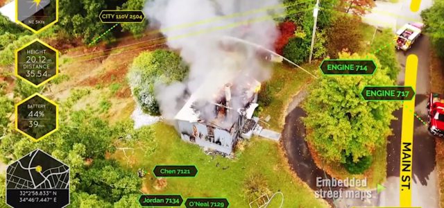
Aerial drone footage has been invaluable in helping first responders evaluate wildfires, and now California startup Edgybees has added an augmented reality (AR) overlay to the drone arsenal. Company marketer Samantha Sharpe notes that Edgybees is being used by first responders on the ground and in command and control centers with live, critical geographical data.of drone footage with mapping technology to give first responders real-time footage of their surroundings. She notes that Edgybees’ First Response software was developed for first responders engaged in complex emergency scenarios. “While it can also be used with CCTV and other kinds of cameras, First Response is being implemented on drones to assist first responders’ efforts in Northern California. By using Edgybees’ AR overlaying mapping technology, firefighters are able to see where gas mains and power lines are, houses and street names, and the locations of team members- regardless of the smoke and fire obstructing their view.”
The Edgybees website notes that its technology “uses computer vision, multi-sensor data analytics and 3D video generation to provide a simple visual layer of highly accurate, real-time information. The result is instant clarity and collaboration within even the most complex operational environments.”