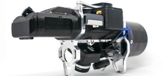
The first sensor of the product line, the True View 410, was displayed at the reveal along with full workflow processing in the companion True View Evo processing software. The True View 410 is the industry’s first integrated LIDAR/camera fusion platform designed from the ground up to generate high accuracy 3D colorized LIDAR point clouds. Featuring dual GeoCue Mapping Cameras, a Quanergy M8 Ultra laser scanner and Applanix Position and Orientation System (POS), the result is a true 3D imaging sensor. With its wide 120° fused field of view, the True View 410 provides high efficiency 3D color mapping with vegetation penetration in a payload package with a mass of about 2 kg.
Demonstrations of True View Evo full post-processing workflow software (included with the sensor) were provided. The audience witnessed the creation of stunning 3D colorized point clouds with processing time from sensor to final product of less than 15 minutes for a 50-acre site. The visualization of colorized vertical surfaces demonstrated the value of the dual oblique cameras and true 3D mapping of LIDAR points to images.
“Anyone considering a drone LIDAR system should pause and evaluate the True View product line,” said Lewis Graham, President and CTO of GeoCue. “The True View sensor fusion systems will make 3D colorized point clouds a standard product demanded by customers of high accuracy drone mapping. The 3D colorization approach that we use in our Evo software provides a new level of intelligence in LIDAR point clouds. An advance in sensor technology comes along every few years that changes our industry – True View is one of those instances.”
The True View 410 beta program begins in July with customer shipments to follow.
Contact GeoCue at 1-256-461-8289 or info@geocue.com for detailed system information.